Number of participants: minimum 2, maximum 8
Included: The tour, meals (breakfast, lunch, dinner), snacks, water, assistance card, bicycle, lodging, etc.
Limitations and restrictions:
– Be in optimal physical condition and not have any health restrictions that would prevent you from safely completing the route.
– According to weather conditions the tour may be delayed.
– Safety equipment: helmet, gloves, etc.
Observations
– The tour must be scheduled in advance, only 50% of the value of the tour can be reserved.
Directions
Salento is a Colombian municipality in the department of Quindio. It is perhaps the most important municipality for tourism in this region. It is considered one of the most beautiful towns because of its beautiful and preserved architecture, a legacy of the Antioquian colonization, its square and old colorful houses in wattle and daub and mud walls, the kindness and gentleness of its inhabitants and the artistic street demonstrations.
In its rural area is the imposing Cocora Valley, known as the cradle of the national tree “La Palma de Cera” and entrance to the National Natural Park Los Nevados, all together generates a contagious atmosphere of peace and well-being that permeates immediately upon arrival.
With an average temperature of 18 degrees Celsius and an altitude of 1800 meters above sea level.
Jardín is a Colombian municipality located in the department of Antioquia. It is part of the Network of heritage towns of Colombia. Cataloging as one of the most beautiful towns in Colombia. A very colorful and cozy paisa town with a great biodiversity, surrounded by mountains, waterfalls and natural viewpoints. With an average temperature of 22°C and an altitude of 1,500 to 3,000 meters above sea level.
Considering the above, it is an ideal environment for the development of outdoor activities that allows us to discover and marvel at its culture, landscapes, flora and fauna.
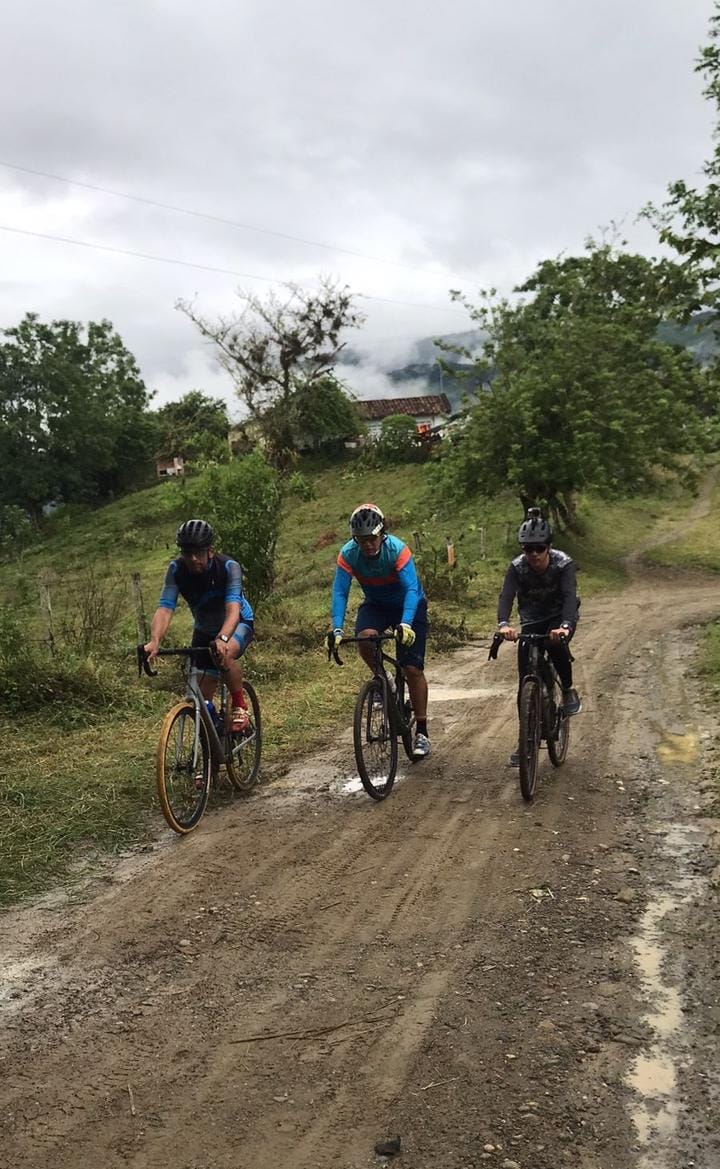
In Salento Trekking we have designed a 3-day bicycle route.
Day 1. Salento Quindío – Santa Rosa de Cabal Risaralda.
We leave from the Salento Trekking office located in the urban area, towards the Vereda Palestina of Salento Quindio, this is an unpaved road, 5 kilometers long. During this journey we begin to connect with nature finding beautiful landscapes, coffee farms, coffee plantations, banana, banana and pine trees, we cross the rivers Navarco and Quindio. We continue with an ascent of 3 kilometers to later exit to a national highway Armenia – Pereira (Panamerican Route) double line road. We continue climbing up to the high known as the oak, with an altitude of 2,300 meters above sea level, mythical road used for international and national races. For 12 kilometers. We begin the descent until we find the road that leads to the Vereda El Manzano – La Florida, which belong to the municipality of Pereira and the department of Risaralda. The trail is mostly on a mixed terrain, through agricultural crops and farms that offer at several points of the route an unbeatable view of the Otún River Valley. During the tour we find: Guaduales, waterfalls, and one of the places with more species of birds in Colombia and many cyclists who go up and down the trail. On this road we ride 3.9 kilometers and begin the 4% descent.
For 6 kilometers we continue along the route La Florida – Santa Rosa de Cabal, a trail of descents and ascents in the middle of pine forests and nature, we cross the Santa Helena stream until we find a waterfall of 60 meters, then we begin an ascent of 1 kilometer and 6 kilometers of descent to Santa Rosa for a total of 23 kilometers, the estimated time for this tour is 5 hours, lunch is at a restaurant in the area and we sleep in a hostel in the municipality of Santa Rosa known for its hot springs and its mild mountain climate.
Additional afternoon options: Visit to the Santa Rosa hot springs.
Day 2. Drive Santa Rosa de Cabal Risaralda. – Riosucio Caldas
This day we start at 1,720 meters above sea level in the municipality of Santa Rosa, we ascend 5 kilometers to begin the journey to Irra, Corregimiento De Quinchía in the department of Risaralda, to connect with the Department of Caldas. We will observe cocoa and coffee crops.
Throughout the journey we border the Cauca River, the second largest river in Colombia, we begin a 4.5 kilometers ascent to 2,300 meters above sea level, where we can find high Andean forest, avocado plantations and Australian pines, and in the distance we can see the departments of Risaralda and Caldas. From the highest point we begin to descend for 5 kilometers 300 meters until we reach the coffee zones.
We continue with a descent of 9 kilometers, until we enter the municipality of Chinchiná in the department of Caldas through the bridge La Ínsula, until we find the San Francisco – La Esmeralda Reservoir and Forest, where the Chivor Hydroelectric Power Plant works, the first hydroelectric power generator built in the country. This tour is very attractive because we can find a Semi-Dry Tropical Forest with a high biodiversity, a large list of bird species, considered a site of high ornithological interest. We can also find orange and tangerine crops.
To strengthen the route during this 11 kilometer ride, we will take a typical transport called “las brujitas”, where we cross the native forest to the municipality of Arauca Caldas, where we stop for lunch. From there, we make an ascent of 2.5 kilometers by paved road, and begin the gravel for 21 kilometers. In this section we cross 2 rivers of crystalline waters, and the contrast of a clay soil of yellowish brown and reddish brown colors, with abundant stone and gravel (river material), caused by the presence of materials of igneous origin and the erosion of the area. This section ends in Irra and there we will take a transport that will take us to Riosucio, a Colombian municipality located in the Eje cafetero and in the paisa region, recognized by its carnival of the devil and its great number of typical festivities, it has a temperate climate of 18 °C, and an altitude of 1,783 meters above sea level. The estimated time for this tour is 8 to 10 hours. We will sleep in a hostel in the municipality of Riosucio.
Day 3. Route Riosucio Caldas – Jardín Antioquia
The municipality of Riosucio is located in the northwestern sector of the Department of Caldas, on the eastern slope of the Western Cordillera of Colombia, with undulating topography, has all climates, from the warm on the banks of the Cauca River to the paramuno at 3,300 m. s. n. m., predominantly cold weather. Taking this into account, this day we start at 8 am, by paved road uphill for 7 kilometers, then we enter the trail and travel 18 kilometers. During this journey, we can observe the diversity present in the municipality and its surroundings, finding species of flora such as black cedar, mountain cedar and red cedar, oak, Colombian pine, black anthurium, cold earth ceiba and more than fifty orchids. Among the fauna we can see birds such as the spectacled sparrow, the candela cacique and the yellow-eared parrot, many of these species are threatened and endangered. Passing through the high Andean forest at 2,500 meters above sea level and then begin a descent of 23 kilometers to finish the tour in the municipality of Jardín Antioquia. The estimated time for this tour is 6 to 8 hours. For a total of 52 kilometers. There we will deliver your luggage and personal belongings so you can continue on your way. We close with a farewell lunch.